Home
> Home page
> News
> Jour 3 - Lundi 17 octobre
Jour 3 - Lundi 17 octobre
Après une nuit de pluie laissant présager le pire, c’est finalement au sec que le jour 3 se lève sur Mimizan. À l’ordre du jour : réception du matériel, installation et initialisation des géophones, et creusement de trous pour chacun d’entre eux...
En début de matinée, les capteurs tant espérés arrivèrent enfin, après avoir traversée l’océan atlantique et la France du Nord au Sud.
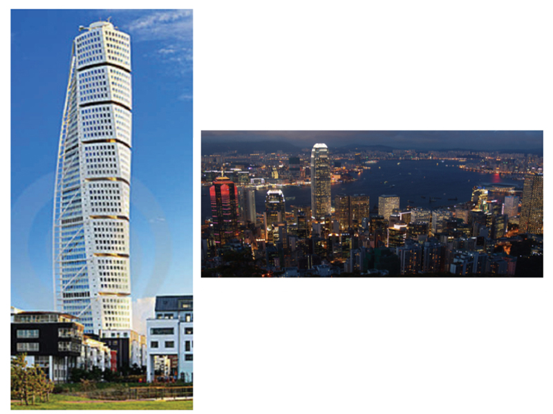
Figure 1.
Tall buildings are classically described as resonators in the field of earthquake engineering (left). Dense modern cities can maybe also be interpreted as a cluster of resonators that are organized as sub-wavelength resonators for seismic waves generated during earthquakes (above). Investigating continuous ambient noise acquisitions performed with seismometers in a collection of buildings (e.g., as recorded by the Building Research Institute in Tokyo for monitoring purposes) would pave the way to metamaterial physics at the seismological scale.
Grâce à l’aide d’Ivan, agriculteur bio de son état et propriétaire du terrain, les 1000 capteurs à déployer sur le site sont réceptionnés en douceur.
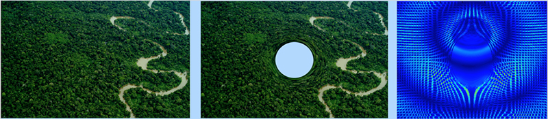
Figure 2.
Forest designers with morphing algorithm: Following the bold proposal of (Pendry, Schurig and Smith, 2006) of an invisibility cloak via radial stretch of coordinates, one can use morphing techniques to map a forest (left) onto a forest with an invisibility region (middle). A 2D numerical simulation (SimSonic2D) shows that a low frequency seismic wave has anisotropic features in the neighborhood of the exclusion area where the elastic field amplitude is lower.
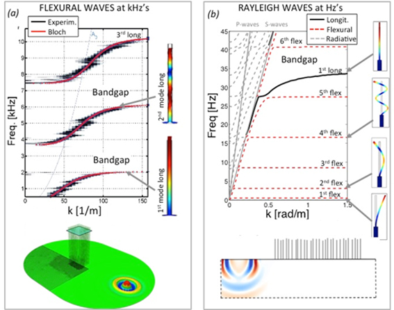
Figure 1.
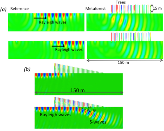
Comparison between metamaterial wave physics at the lab scale and in geophysics. (a) Dispersion curves measured (black) and computed with Bloch theory (red) for the case of vertical beams attached to the plate. Arrows point to the respective modal deformation. (b) Same as (a) but for the case of the trees on a semi-infinite geophysics half space. The S-wave line bounds the radiative zone on the left, which is not involved in the analysis.
Avant de démarrer les opérations, l’équipe de METAFORET hisse les couleurs sur les pins des Landes.
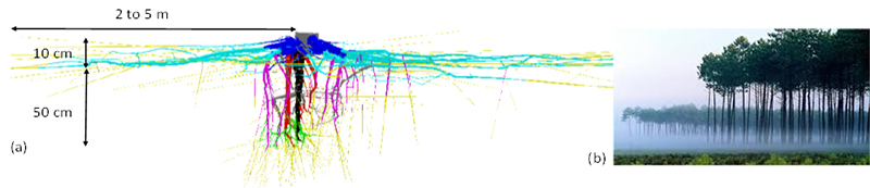
Figure 1.
(a) Detailed root system architecture for the maritime pine tree. The roots coordinates were measured with a 3D digitizer using low frequency electromagnetic fields sensing (from Danjon et al., 2013). (b) Picture of maritime pine tree forest in the Landes department showing trees without lateral branches until 10-m height
En utilisant le quadrillage tracé la veille, l’équipe entreprend ensuite de positionner les géophones.
Figure 1.
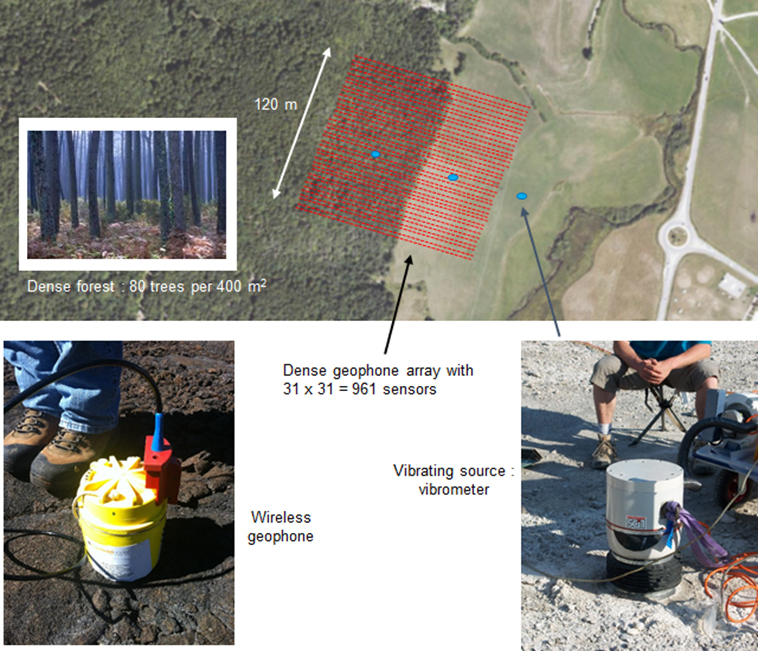
Top: Configuration of the META-FORET experiment. The goal is to install 961 three-component geophones on a 120 m × 120 m grid with 4-m inter-element spacing. The seismic array (red) is placed across the interface of an open field and a dense pine-tree forest (80 trees per 400 m²). Bottom left: Continuous ambient noise recording will be carried out over 12 days with wireless seismic sensors from FairFieldNodal. Bottom right: As well as this ambient noise, active source signals will be recorded using a vibrometer source positioned at different locations (top: blue elipses) in the open field (inside and outside the array) and inside the forest.
Figure 1.
Model of the Luneburg lenses. Each lens is obtained with radially varying (d) inclusions. (b) The required and resulting velocity profile obtained using the effective material approach. (c) Preliminary 3D simulation results of the cloak.
Puis, chaque capteur doit être calibré individuellement, et sa position enregistrée. Les nouveaux arrivants Adeline, Chloé, Lise et Gregor ne sont pas de trop pour cette longue journée.
Figure 1.
(a) Preliminary 2D simulations on the meta-forest.
(b) The meta-wedge capable of converting Rayleigh waves into shear waves.
Figure 1.
Soda can metamaterial under experimental investigation in a homemade anechoic room. Twelve speakers, connected to a multichannel soundcard, can insonify the metamaterial sequentially while a microphone mounted on a 2D translation stage records the wave field at any position in the near field of the sample
Afin d’améliorer le couplage entre la terre et les géophones, ceux-ci sont finalement enterrés. C’est ici que les bêches et autres pioches interviennent. Les travaux avancent bien grâce à la frénésie excavatrice de Philippe et Johannes. L’objectif est de finir l’installation complète du réseau sismique avant demain midi.
Figure 1.
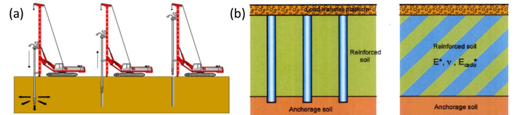
(a) Construction process for Controlled Modulus Columns; (b) Composite column/surrounding soil material (left) which act as a ground improvement with equivalent deformation modulus parameters (right).
Figure 2.
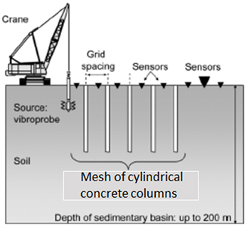
Example of experimental configurations with buried concrete colomns as proposed by Menard with controlled modulus columns.
Isabelle accrochée à son râteau... Marc-Antoine au loin.